URA Space is a centralised integrated map portal you can use to understand the URA Master Plan. It is an online map tool that gives you detailed information on Singapore’s future land use plans and plot ratios. Whether you’re a buyer, an upgrader, or an investor, you want to know how to use this essential tool to better understand how land is used in Singapore.
Simply put, if you have a stake in Singapore property, then consulting the URA Master Plan is pretty much a ‘must read’ as it provides you with the government’s master plan to develop Singapore in the next few years.
Knowing how the government plans to develop an area ahead of time will give you a competitive advantage. It is a good way for analytical real estate ‘flippers’ or investors to gain insight into which neighbourhoods in Singapore may become expensive residential areas. But first, you’ll need to understand how to read it. Here’s an easy four step guide on how to read Singapore’s URA Master Plan using URA Space.
What is the URA Master Plan?
The Urban Redevelopment Authority (URA) defines the URA Master Plan as “a statutory land use plan that guides Singapore’s developments in the medium term over the next 10 to 15 years”. In simple terms, the URA Master Plan is a future roadmap for developments across Singapore up to the next 15 years, laid out bare to you.
Since all land in Singapore is zoned according to its uses (e.g. residential, commercial, transportation, etc.), the Master Plan acts as a semi-blueprint of the country’s development and contains details such as allowable land use and density of developments. It is also reviewed every five years.
By understanding the plan, property buyers hold a ‘crystal ball’ in their hands as they have ‘first-hand’ information on future developments in Singapore. With this ‘crystal ball’, you can get an idea of what future developments may impact the quality of living, and the likely value of a property you are interested in.
Every 10 years, the URA reviews its long-term plan for Singapore. In the latest review, URA revealed that in the next 50 years, we’ll see more mixed-use developments, a better mix of public and private housing in the Bayshore, Upper Changi neighbourhoods, new parks and nature corridors, and the redevelopment of the Paya Lebar Air Base, among other plans.
Comparing the 2019 URA Master Plan and the previous 2014 iteration, you can easily see what has changed at a glance.
Using URA Space for Long-Term Planning and Understanding the URA Master Plan
Now that we got the basics out of the way, here comes the tricky part: understanding how to read the map. For a newbie who hasn’t been exposed to the URA Master Plan before, it can be quite daunting, especially with all the terms and colour-blocked areas.
If you find it challenging to make sense of the URA Master Plan, here’s a handy step-by-step guide to help you.

Pre-Requisite 1: Learn to Read URA Master Plan Legend on URA Space
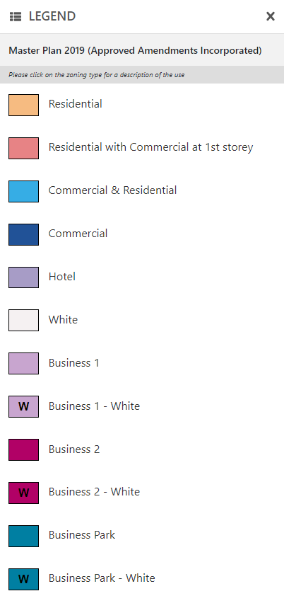
To understand the URA Master Plan Legend, you need to first learn about the meaning behind each colour code on the URA map.
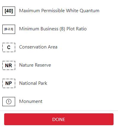
To get the full URA Master Plan legend, click on ‘Find Master Plan Zoning’ on the first page. Then click on ‘Legend’, located right beside the main menu to understand what each colour code stands for. As you move through the map, you can click on the ‘Legend’ button to reference what you’re looking at.

Once you click the button, you can see the following details, which displays the colours and states which ‘zone’ they are representing (as detailed below):


As you can see, each zone is colour-coded according to what the land can be used for. You can also check what each colour represents by looking at the URA master plan legend. Generally, the key takeaways are these:
Residential/ Commercial & Residential
Beige, light blue
The most important colours you need to know are the beige and blue areas. These areas indicate where there will be property developments for residential homes.
Educational institutions
Off-white with an ‘E’ inside
If you have children of school-going age (or planning to have children), having a choice school nearby can be a big draw. Take note that the noise generated from schools can be substantial during recess and dismissal times.
Health and medical care
Red with an ‘H’ inside
Areas zoned for healthcare usually mean hospitals, polyclinics, or other developments such as rehabilitation centres or hospices. If you live with your parents or an elderly family member or friend, staying near a healthcare facility can be vital, especially if they require frequent medical attention.
Transport facilities
Symbol with lines drawn across, depending on the transport type
Being close to transport facilities like MRT stations can have a large impact on the prices of properties. HDB blocks that are within walking distance of an MRT station usually fetch higher prices than those that are significantly farther away.
However, if a unit is too close to the MRT tracks, it can also be a deterrent due to the constant noise.
However, if a unit is too close to the MRT tracks, it can also be a deterrent due to the constant noise.
Commercial & Residential/Commercial (retail, office)
Light blue, blue and baby blue
Having a shopping mall or a selection of retail amenities nearby where you live is a very attractive prospect. After all, everyone likes convenience. It’s also one of the ways COVID-19 has changed the way we buy property.
Pre-Requisite 2: Plot Ratio
Apart from deciphering the land use and its zones, another vital thing to know when exploring areas to purchase property is the plot ratio.
The plot ratio tells you how intensively a plot of land can be used for developments; for example, how likely it is to contain skyscrapers or tall buildings. The plot ratio determines the maximum gross floor area (GFA) of any development on that land parcel. That’s why plot ratios can be a useful indication of potential developments in an area.
If you zoom in on the URA Master Plan via URA Space, you’ll notice that each plot has a number (e.g. 2.9, 3.0, 3.5). This is basically the plot ratio of the parcel of land. The larger the number’s value, the more intensively the land can be used. Meaning to say that a high plot ratio will have more units and more storeys.
If you’re buying a residential project, you could roughly estimate the number of storeys and density based on the plot ratio:
| Gross plot ratio/density | Storeys |
| 1.4 (very low density) | 5 |
| 1.6 (low density) | 12 |
| 2.1 (medium density) | 24 |
| 2.8 (high density) | 36 |
| > 2.8 (very high density) | >36 |
If two plots of land have similar areas (on the URA Space map), but differing plot ratios, it usually means that one will be denser or taller than the other.
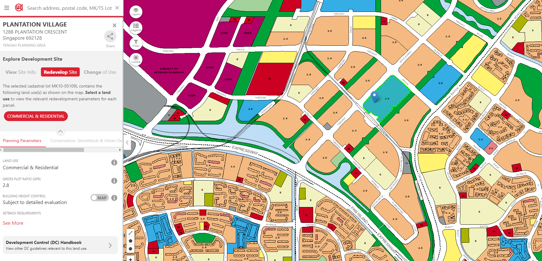
You can look up the maximum allowed height for buildings in certain plots using the search bar. Simply input the address or name or click an area on the map, and then click on ‘Redevelop Site’ and you’ll be able to see the maximum height of the building.

So why does plot ratio matter? Well, that’s because the plot ratio indicates how tall the buildings will be on the specified plot of land. In other words, if the plot ratio number is high, it’s more likely that the land will have a tall building.
Residential plots with a high plot ratio can mean towering condo blocks while a commercial land area could be a new shopping mall.
Looking at the plot ratio is pivotal as you don’t want to buy an expensive condo and end up having your view blocked by another condo that is due for development in three years. This can seriously affect your property’s valuation!
Buying Property: What Should I Look Out for In the URA Master Plan?
Step 1: Zoom in on Your Area of Interest
The first and most helpful step to know before you use the URA Master Plan is to have an area of interest.
Otherwise, it is akin to exploring the world map to look for a travel destination. You will be overwhelmed with choices and end up with a choice dilemma.
Let’s say you are eyeing a new BTO with your other half. Based on the upcoming BTO projects, you can then select your area of interest. For example, the upcoming developments in Tengah can be viewed when you zoom in on the Tengah town.


Step 2: Identify the Key Features of (and Around) Your Desired Plot

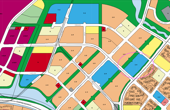
Using the URA Master Plan, you can find out that a residential and commercial plot will be released in the upcoming BTO project in Tengah. A residential and commercial plot indicates that it will be a mixed development with the potential of having a mini-shopping area within the neighbourhood.
There might even be a food centre within the plot that will be very convenient for your food needs. Using the latest update on URA Space, you can overlay different maps onto each other and even change their opacity for a better view.

For example, the commercial shops for Plantation Village (as indicated on the URA Master Plan) will be along the green space in the middle of Plantation Village and Plantation Grove.

Parc Residence, launched in the August 2020 BTO, was another mixed development plot (blue area), just like Plantation Village. The BTO project just diagonally across Plantation Village houses the neighbourhood centre where you will find shops, a community centre and a polyclinic under one roof.
Another feature you can identify from the URA Master Plan is that the plot will be one street away from the MRT (Tengah Plantation). From a transport perspective, this plot is very convenient, especially once the Jurong Region Line (JRL) is complete.
For sports lovers, there is also a stadium located within the vicinity (on the top right of the image). Not only that, but you can also see that there is a green strip between the plots in Tengah, which indicates a potential park connector. If you are a nature lover, this will help tick more boxes off your checklist.
Step 3: Avoid ‘Undesirable’ Areas
As you read through the 2019 URA Master Plan, you might notice some ‘undesirable’ areas that should be avoided.
One such example may be Business 2 (heavier industries) areas. As these areas generally emit a lot of air and sound pollution, living near these heavy industries will mean that there will be lots of factories emitting carbon dioxide and loud noises.
Apart from that, living right next door to a place of worship can also be less than desirable to some due to the large crowds they draw during prayer time or significant religious festivals. Some may find living next to a columbarium to be inauspicious; the same goes for living near a hospital.
That’s why it’s important to make sure that you know what you are getting into before you commit to buying a property, lest you end up regretting your purchase.
For those who are purchasing a home with a view, it’s also good to check the plot ratios of the surrounding land plots. If the plot ratio is low, then you can be assured your unblocked views will remain for a long time. The last thing you want is to fork out a price premium for a high floor unit only to have a new shopping mall or condo built right in front of your home.
Step 4: Estimate the Worth of Your Desired Plot using URA
If you are buying the property for investment, then you can also use the URA Master Plan to estimate the worth of your desired location.
While it is almost impossible to predict the future price of the development, you can certainly gauge the worth by comparing it with similar plots in the vicinity (e.g. Tengah vs Jurong West/Bukit Batok).
The URA Master Plan can also give you a clue of the upcoming developments in the area that could drive your property’s prices (e.g. MRT, business parks).
While the URA Master Plan Is Detailed, There Are Limitations to It
While the URA Master Plan is quite useful when it comes to making property decisions, it should not be used as your sole source of information. Sometimes, it can be difficult to execute the plan, even with a roadmap in place. That’s why the URA Master Plan is reviewed once every five years.
That being said, consulting the URA Master Plan can give you an idea of how the land in the vicinity is going to be used, as well as how dense it can get, though it doesn’t give you the details of what exactly will be built there. An MRT station is a big difference from a bus interchange, for example.
Thus, it is important to supplement your research with news and updates from URA and LTA on developments in the area as you keep an eye out for updates.
For more property news, content and resources, check out PropertyGuru’s guides section.
Looking for a new home? Head to PropertyGuru to browse the top properties for sale in Singapore.
Need help to finance your latest property purchase? Let the mortgage experts at PropertyGuru Finance help you find the best deals.
Disclaimer: The information is provided for general information only. PropertyGuru Pte Ltd makes no representations or warranties in relation to the information, including but not limited to any representation or warranty as to the fitness for any particular purpose of the information to the fullest extent permitted by law. While every effort has been made to ensure that the information provided in this article is accurate, reliable, and complete as of the time of writing, the information provided in this article should not be relied upon to make any financial, investment, real estate or legal decisions. Additionally, the information should not substitute advice from a trained professional who can take into account your personal facts and circumstances, and we accept no liability if you use the information to form decisions.


